
Accurate information at your fingertips. Take 30 seconds to see for yourself how quickly and easily you can find accurate data in minutes.
Accurate information at your fingertips. Take 30 seconds to see for yourself how quickly and easily you can find accurate data in minutes.
“I really like the planning and flooding layers as this is an excellent source of easy to access information. These are two layers that makes Promap stand out as being the first place I would go to obtain this information. Trawling through the council websites is a pain to obtain this information, so this saves me a considerable amount of time.”
James Day, Hamptons International

How to spend 3 hours in London
If you find yourself in London for 3 hours, and you time it right, you can take some photos of Westminster Abbey and Number 10, admire Big Ben, watch the changing of the guard, climb the lions in Trafalgar Square, and even squeeze in a sandwich.
But, what can you do in 3 hours as a surveyor based in London? Check local planning applications. No time for a sandwich.
Use different data layers to give you a clearer picture
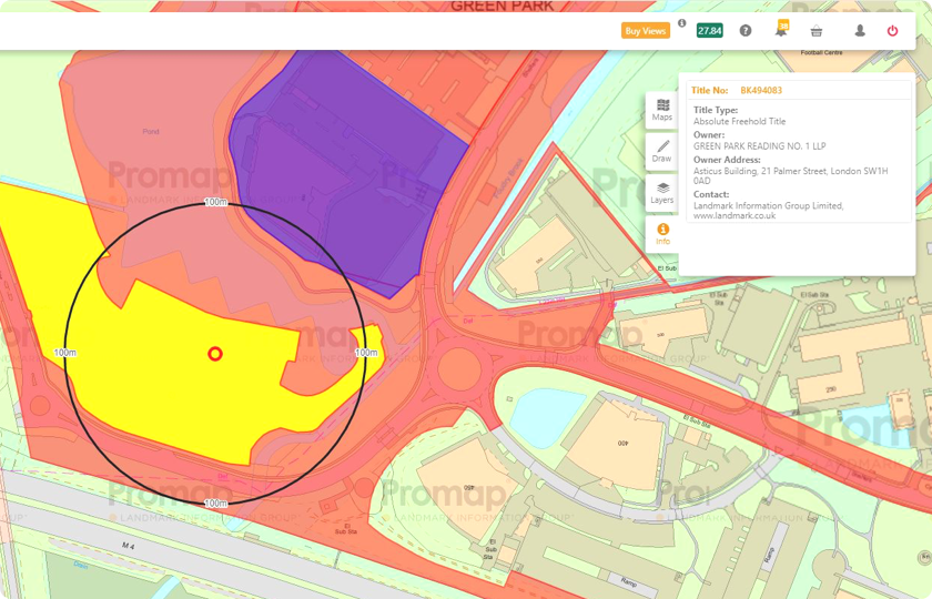
I’ve been asked to find a site for a commercial real estate property in Berkshire. There are a couple of places I’ve had on my radar, so I went on Promap to take a closer look.
I checked out one place. And, by checking the local data category of Promap Premium Data Layers, I’ve found out it’s an area of core employment. That can go either way, but when I overlaid planning applications, I saw there were no planned developments.

Use data insights to grow your portfolio
I work in a beautiful part of the country. Because I live here, and my children live here, I’m always looking for a way to develop the area responsibility. Every community needs growth, but it’s important to work with people in a sustainable way.
Anyway, I’ve been running my own business for a few years now. It hasn’t always been easy, but I’ve had some really great projects and built a good reputation. So, now I really want to concentrate on growing my portfolio a bit.
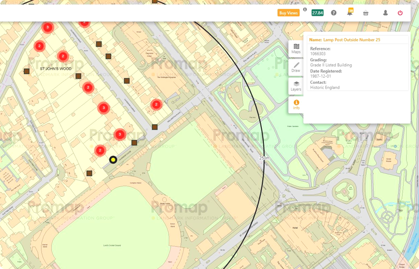
There is so much data about London, it’s an architect’s dream
I’m new to London and only qualified as an architect in 2017, so I still need to make a good impression on my boss. All those late nights and coffees must have been paying off because last week he gave me a big opportunity to quote for a design on a central London property. I really need to impress him with an accurate and competitive quote.
Moving into the new decade, I am more aware than ever that the role of the architect is changing, and you’ve got to be a bit more tech-savvy than ever. You have to take advantage of all the improvements in land data to stay afloat, never mind get ahead, so I use Promap.
Premium Data Layers contains all the accurate data sets you need for up-to-date information on planning, personal ownership, listed building, greenbelts and more. Add value to your clients by providing this data quickly, with meaningful quotes and timescales.
Includes planning applications submitted to local authorities throughout Great Britain via local authority weekly planning lists. The data includes large, small and minor applications which are split on the basis of estimated project value.
This dataset contains Title numbers for non-commercial polygons across England and Wales. This dataset does not provide any information regarding the owner.
This data contains information about the sales of single residential properties which are sold for full market value to private individuals in England and Wales, which have been submitted to the Land Registry (HMLR) for registration.
Includes areas that are deemed to be of natural importance and have restrictions that may limit the extent and type of property development that can take place. Land Use Constraints Data includes;
OSMM Highways Network brings together data from authoritative sources such as the National Street Gazetteer (NSG) and OS Large Scale Road data to create a single authoritative view of the road network.
Promap is a Landmark Information Group Ltd. company.
Registered Office: 5-6 Abbey Court, Eagle Way, Exeter, Devon, EX2 7HY, . Registered Number 2892803 Registered in England and Wales.
The information contained in this e-mail is confidential and may be subject to legal privilege. If you are not the intended recipient, you must not use, copy, distribute or disclose the e-mail or any part of its contents or take any action in reliance on it. If you have received this e-mail in error, please e-mail the sender by replying to this message. All reasonable precautions have been taken to ensure no viruses are present in this e-mail. Landmark Information Group Limited cannot accept responsibility for loss or damage arising from the use of this e-mail or attachments and recommend that you subject these to your virus checking procedures prior to use.